

Weather could impact Coosa, Elmore and Tallapoosa counties Thursday night into Friday.
The National Weather Service gave a briefing Wednesday morning as local officials attended via a webinar.
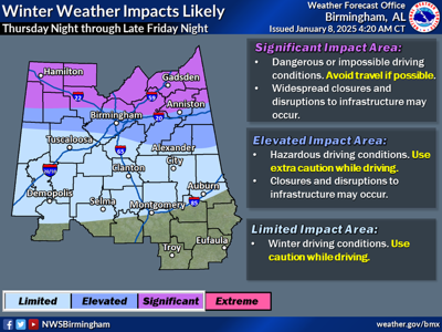
“We expect the northern portions of Alabama to see significant impacts with some accumulations of snow and sleet,” Jason Davis with the National Weather Service said. “Travel is expected to become very difficult or impossible for counties within the newly issued winter storm watch.”
The winter storm watch is for areas primarily north of Birmingham but predictions for Coosa, Elmore and Tallapoosa counties indicate the area could see less than half an inch of snow. There are also chances of sleet and freezing rain.
Davis said the impact is expected to be minimal for the area with most of the concern being for the Friday morning commute. He said the further north you get the chance for higher accumulation was greater.
“In all cases, the greatest chance of snow is after midnight Thursday going into Friday morning,” Davis said. “The temperatures will be hovering around freezing.”
Davis said there is also some concern about Friday night as precipitation was still a possibility.
“Select hazardous road conditions are expected to continue through Saturday morning as temperatures fall below freezing once again Friday night,” Davis said.
In Tallapoosa County, the Alexander City Municipal Complex will be open for a warming station. In Camp Hill Mt. Lovely Missionary Baptist Church and First Universalist Church will open.
In Tallassee, the basement of the Tallassee Police Department and the municipal courtroom at the Tallassee City Hall will be open through Friday afternoon.
Davis said there will be another update at 10 a.m. Thursday.


