
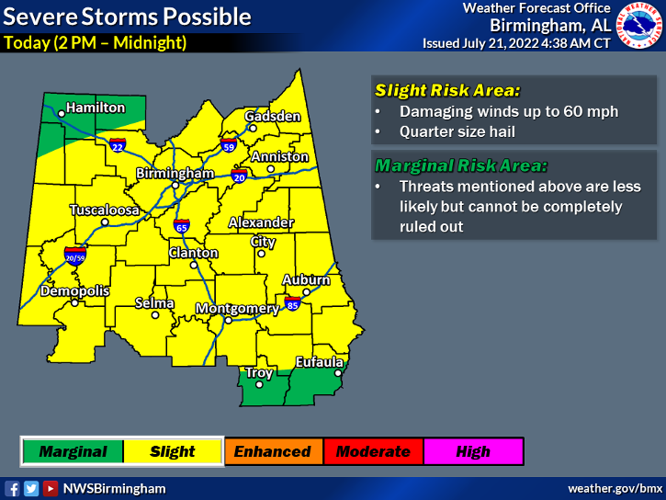


Anyone who has lived in Alabama for a season knows how the weather can change at the drop of a hat. Alabama’s weather is on display again today as a threat for severe storms lingers until midnight and a heat advisory is in place until 7 p.m., Thursday, July 21.
According to the National Weather Service, storms that develop this afternoon could produce wind gusts up to 60 mph and quarter size hail. Coosa, Elmore and Tallapoosa Counties are in a level two out of five risk category for severe storms, as is much of central Alabama. Residents can anticipate storms forming around 2 p.m.
The National Weather Service has also placed Coosa, Elmore and Tallapoosa Counties in a heat advisory until 7 p.m. The heat advisory is in place due to heat indices climbing to 110 degrees in some places and 105 degrees in other places.

Heat indices could reach 110 degrees in some part of central Alabama today.
The National Weather Service urges residents to use caution if outside for extended periods of time.
“Use caution if outside, drink plenty of water and take frequent breaks,” said the heat advisory description put out by the National Weather Service. “Don’t forget your pets!”
As of noon, Thursday, July 21, the heat index at Thomas C. Russell Field Airport in Alexander City was already at 101 degrees with 71 percent humidity.
Also, by noon, storms had already begun forming to the east of the area, toward the Georgia state line, traveling westward.
Once the threat of severe weather is over, residents can look forward to a mostly sunny weekend with highs in the low 90s and lows in the mid 70s.

